Replay · WS20170209
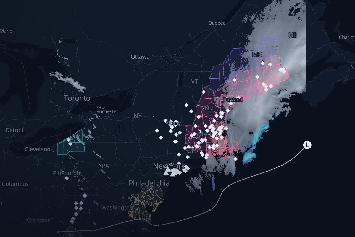
Blizzard of February 9–10, 2017: the story
Feb 9, 00:00 UTC – Feb 10, 12:00 UTC. Radar showing snow and rain, winter warnings, storm reports and the surface low's track from the Weather Prediction Center, in order. NCEI's Northeast Snowfall Impact Scale rates it Category 1, Notable (NESIS 1.87), and ranks it 71st on its list.
- 73 NWS warnings
- 3,161 storm reports
- 12 WPC surface-low analyses
- 10 FAA airport programs
- 1 8-Ks naming the storm
- 10 rule-based links
- 217 radar frames, 10 min apart
Chapter 1: First warnings
Feb 9
- NWS New York, NY issues the first Blizzard Warning.Replay from here
- The strongest wind reported: 71 mph at 4 NE Calverton, NY.Replay from here
Chapter 2: The bomb
Feb 9–10
- Bombogenesis: the low's pressure has fallen 29 mb in 24 hours, to 973 mb.Replay from here
- The low is at its deepest: 970 mb.Replay from here
Chapter 3: The snow totals
Feb 10
- The largest snow report: 24 in at 1 SE Cooper, ME.Replay from here
Chapter 4: Aftermath
Feb 10–Mar 10
- The aftermath: 1 8-K names the storm after it ended, the last on 2017-03-10.Replay from here
How we link records
| Rule | What it checks | Links |
|---|---|---|
| R3 solid | An SEC 8-K that names the storm | 1 |
| R2 dashed | An airport program inside a warning that had been in effect for over 60 min (context) | 8 |
| R1c solid | A weather airport program inside a convective warning or watch, within 60 min of issuance | 1 |
Solid lines mark rules that passed an independent check; dashed lines are context. Links are rule-based facts: each shows two records that overlap in place and time. How we know
Where this storm's data comes from
Every layer, the provider behind it and the period it covers.
| Layer | Provider | Period | Records |
|---|---|---|---|
| MRMS SeamlessHSR | NOAA/NSSL via Iowa Environmental Mesonet | Feb 9, 00:00 UTC – Feb 10, 12:00 UTC | 217 |
| NWS storm-based warning polygons | NOAA National Weather Service via Iowa Environmental Mesonet | Feb 9, 00:00 UTC – Feb 10, 12:00 UTC | 73 |
| NWS Local Storm Reports | NOAA National Weather Service via Iowa Environmental Mesonet | Feb 9, 00:00 UTC – Feb 10, 12:00 UTC | 3,161 |
| WPC coded surface bulletins | NOAA Weather Prediction Center via Iowa Environmental Mesonet | Feb 9, 00:00 UTC – Feb 10, 12:00 UTC | 12 |
| NOHRSC snowfall | NOAA National Operational Hydrologic Remote Sensing Center | Feb 9, 00:00 UTC – Feb 10, 12:00 UTC | |
| FAA airport programs (ground stops and ground delay programs) | FAA Air Traffic Control System Command Center | Feb 9, 00:00 UTC – Feb 10, 12:00 UTC | 10 |
| SEC EDGAR 8-K filings | U.S. Securities and Exchange Commission | Feb 9, 00:00 UTC – Feb 10, 12:00 UTC | 1 |
- Radar: NOAA/NSSL MRMS SeamlessHSR, via the Iowa Environmental Mesonet (IEM), Iowa State University
- Warnings: NOAA/NWS, storm-based polygons via the Iowa Environmental Mesonet
- Storm reports: NOAA/NWS Local Storm Reports via the Iowa Environmental Mesonet
- Storm track: NOAA/NWS Weather Prediction Center coded surface bulletins, via the Iowa Environmental Mesonet
- Airport programs: FAA Air Traffic Control System Command Center
- Filings: U.S. Securities and Exchange Commission EDGAR
- Snowfall: NOAA/NWS National Operational Hydrologic Remote Sensing Center (NOHRSC)