Replay · WS20201216
Winter Storm of December 16–18, 2020: the story
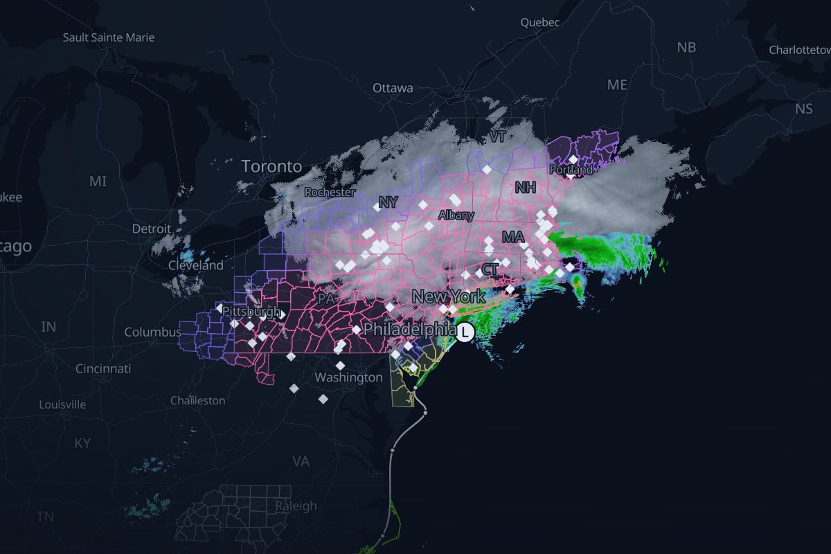
Dec 16, 00:00 UTC – Dec 18, 06:00 UTC. Radar showing snow and rain, winter warnings, storm reports and the surface low's track from the Weather Prediction Center, in order. NCEI's Northeast Snowfall Impact Scale rates it Category 2, Significant (NESIS 3.21), and ranks it 50th on its list.
- 92 NWS warnings
- 5,537 storm reports
- 17 WPC surface-low analyses
- 3 FAA airport programs
- 325 radar frames, 10 min apart
Chapter 1: The storm arrives
Dec 16
The replay opens as the snow begins.
Chapter 2: Overnight
Dec 17
- The strongest wind reported: 74 mph at Eatons Neck, NY.Replay from here
- The low is at its deepest: 996 mb.Replay from here
Chapter 3: The snow totals
Dec 17–18
- The largest snow report: 45 in at Vestal, NY.Replay from here
Where this storm's data comes from
Every layer, the provider behind it and the period it covers.
| Layer | Provider | Period | Records |
|---|---|---|---|
| MRMS SeamlessHSR | NOAA/NSSL via Iowa Environmental Mesonet | Dec 16, 00:00 UTC – Dec 18, 06:00 UTC | 325 |
| NWS storm-based warning polygons | NOAA National Weather Service via Iowa Environmental Mesonet | Dec 16, 00:00 UTC – Dec 18, 06:00 UTC | 92 |
| NWS Local Storm Reports | NOAA National Weather Service via Iowa Environmental Mesonet | Dec 16, 00:00 UTC – Dec 18, 06:00 UTC | 5,537 |
| WPC coded surface bulletins | NOAA Weather Prediction Center via Iowa Environmental Mesonet | Dec 16, 00:00 UTC – Dec 18, 06:00 UTC | 17 |
| NOHRSC snowfall | NOAA National Operational Hydrologic Remote Sensing Center | Dec 16, 00:00 UTC – Dec 18, 06:00 UTC | |
| FAA airport programs (ground stops and ground delay programs) | FAA Air Traffic Control System Command Center | Dec 16, 00:00 UTC – Dec 18, 06:00 UTC | 3 |
- Radar: NOAA/NSSL MRMS SeamlessHSR, via the Iowa Environmental Mesonet (IEM), Iowa State University
- Warnings: NOAA/NWS, storm-based polygons via the Iowa Environmental Mesonet
- Storm reports: NOAA/NWS Local Storm Reports via the Iowa Environmental Mesonet
- Storm track: NOAA/NWS Weather Prediction Center coded surface bulletins, via the Iowa Environmental Mesonet
- Airport programs: FAA Air Traffic Control System Command Center
- Filings: U.S. Securities and Exchange Commission EDGAR
- Snowfall: NOAA/NWS National Operational Hydrologic Remote Sensing Center (NOHRSC)